The Himalayas are unpredictable. But countries are building there like never before

Daftar Isi
- Glacial collapse on the China-Nepal border kills hundreds as Himalayan construction boom faces its starkest test
- A construction surge built on shifting ground
- Climate change compresses the safety horizon
- Geopolitics layered onto geology
- What the catastrophe demands next
- Related Reading
- Frequently Asked Questions
Glacial collapse on the China-Nepal border kills hundreds as Himalayan construction boom faces its starkest test
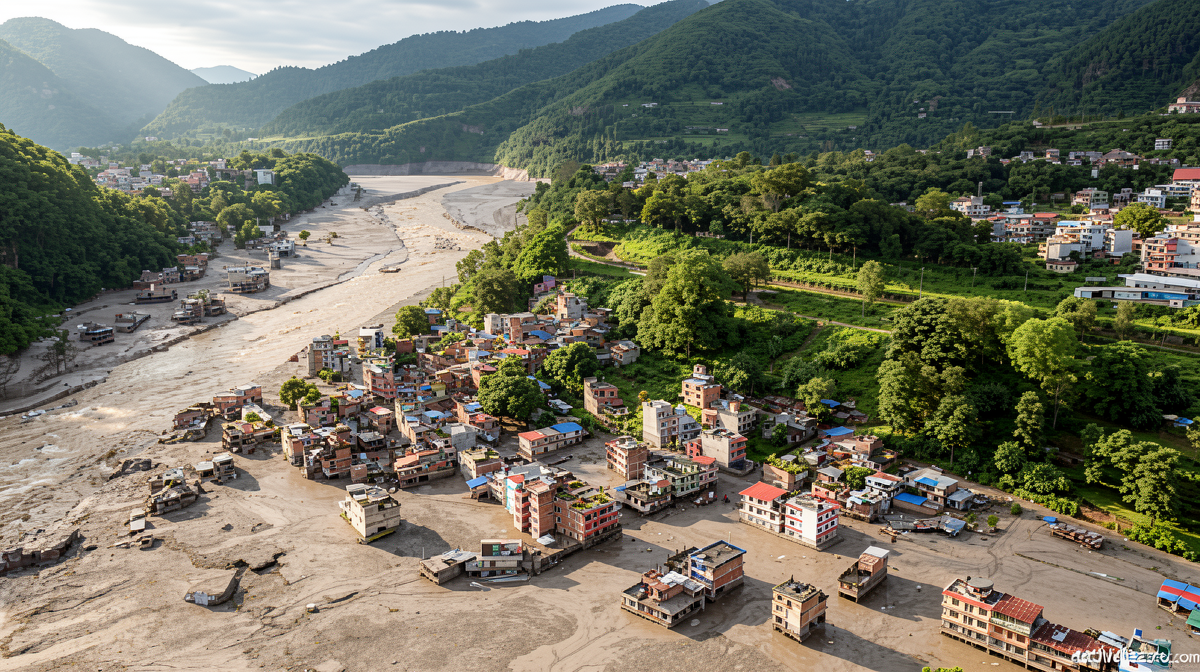
Activelifezero.com – A section of glacier sheared away from a mountain face on Wednesday morning, sending a wall of rock and meltwater cascading down a valley along the China-Nepal border. The resulting landslide and flash flood obliterated villages, severed roads and bridges, and destroyed hydropower installations on both sides of the frontier. More than 600 people have been confirmed dead, and roughly 3,000 remain unaccounted for as search teams work through debris fields that continue to shift.
The event has no confirmed link to human construction. Yet it lands at a moment when governments across the Himalayan arc are pouring capital into dams, tunnels, railways, highways, and bridges at altitudes where the ground itself is unstable. The disaster now functions as an uninvited audit of whether those projects were engineered with sufficient margin for the region’s seismic and climatic volatility.
Rescue operations hampered by cascading hazards
Teams on both sides of the border face conditions that compound with every passing hour. Debris from the initial slide has dammed rivers, creating barrier lakes that threaten to burst and send secondary floods through already-destroyed settlements. Landslides triggered by saturated slopes add another layer of unpredictability. Weather in the upper valleys remains erratic, limiting aerial access and ground mobility.
On Friday, the Polituro Bureau of China’s Communist Party convened under Xi Jinping to assess the response. The leadership acknowledged what it called
“enormous challenges to rescue and emergency response efforts” due to “numerous glaciers, glacial lakes, and potential geological hazards” and variable weather.
The phrasing underscores that the state itself recognizes the terrain as an active adversary, not merely a backdrop.
A construction surge built on shifting ground
The Himalayan range sits atop converging tectonic plates. Its rivers are fed by glaciers that have been retreating at accelerating rates. Millions of residents across the Indian subcontinent’s floodplains depend on the seasonal flow that originates in these high-altitude catchments. The region ranks among the most seismically active and ecologically fragile zones on Earth. Even before climate change amplified hazard frequency, engineers regarded the terrain as demanding. Now the calculus has shifted.
Beijing’s high-altitude energy strategy
No state has mobilized resources for Himalayan development with the scale of China. The government treats Tibet and its borderland ridges as pillars of national security and energy independence. A central element of that strategy is a $168 billion megadam currently under construction in the plateau, a structure whose dimensions push against the outer envelope of what conventional civil engineering has previously attempted. Surrounding it, ultra-high-voltage transmission corridors are being laid to shuttle clean electricity from Tibetan hydropower plants and vast solar and wind arrays down to the industrialized eastern coast.
Beijing has also long used infrastructure investment as a mechanism for consolidating administrative control over Tibetan communities, a practice that predates the current energy push and intertwines economic and political objectives.
New Delhi and Kathmandu follow suit
India has accelerated its own pipeline of Himalayan projects in recent years, channeling hundreds of millions of dollars into road networks, rail links, and hydro schemes in the northern states. Nepal, though smaller in scale, has likewise expanded its hydropower portfolio and mountain-road program. Together, the three governments are reshaping a landscape that was, until a decade ago, largely untouched by heavy engineering.
Climate change compresses the safety horizon
The physics of the disaster is straightforward: warming air destabilizes glacier margins, increases meltwater volume, and saturates slopes that were previously stable. What was once a once-in-a-century flood event is arriving on a five- to ten-year cycle. Design codes written two decades ago no longer describe the threat environment.
Austin Lord, a senior fellow in the Energy, Water, and Sustainability Program at the Stimson Center in Washington, framed the problem in blunt terms:
“We’re getting ‘100 year floods’ every five to 10 years… the climate risks are evolving faster than our ability to shift the margins on what we think are the horizons of safety.”
He added that the multiplicity of unknowns in the region’s hydrology and geology demands coordinated regional work:
“With so many unknowns, if we don’t start working on them together then we won’t make any progress, and we’ll just be overwhelmed again next time.”
Geopolitics layered onto geology
The disaster struck an international border, which means that shared risk monitoring, early-warning data exchange, and joint emergency protocols become not merely technical questions but diplomatic ones. A simmering China-India border dispute along adjacent ridges adds friction to any bilateral coordination effort. Nepal, sandwiched between the two larger states, occupies a particularly exposed position when upstream hazards cascade southward.
Ruth Gamble, an environmental, cultural, and climate historian of Tibet at La Trobe University in Australia, described how the conceptual frame around the mountains has changed:
“The mountains got reframed from being what (the states) saw as a backwater or a place of potential ethnic instability… into being a resource.”
She noted that the motivation extends beyond hydropower to include mineral extraction, tourism development, and what she characterized as a military-industrial complex with its own associated infrastructure footprint.
What the catastrophe demands next
Whether this event triggers a recalibration of design standards, siting criteria, and project scale across the Himalayan arc remains unresolved. Planners in Beijing, New Delhi, and Kathmandu will face pressure to justify continued investment while simultaneously demonstrating that new works incorporate updated seismic, glacial, and climatic risk parameters. Regional bodies may be urged to establish shared monitoring networks for glacial lakes and debris flows—systems that no single country can operate alone given the transboundary nature of the hazards.
The mountains do not negotiate with construction schedules. The question now is whether the governments building upon them will adjust their timelines to match the pace at which the ground beneath their foundations is changing.
Related Reading
Frequently Asked Questions
What is The Himalayas are unpredictable But countries?
The Himalayas are unpredictable But countries is the main topic of this guide. The article explains the context, practical details, and next steps readers should understand.
Why does The Himalayas are unpredictable But countries matter?
The Himalayas are unpredictable But countries matters because readers are looking for a useful answer, not just a short summary. Good content should match search intent and help them decide what to do next.