Rare, high-end tornado threat issued for central US as severe storm outbreak peaks Monday
Rare High-End Tornado Threat Hits Central US as Storms Peak
Rare high end tornado threat issued – A rare high-end tornado threat has been issued for the Central Plains, signaling the height of a severe storm outbreak set to peak on Monday. This rare event underscores the potential for powerful tornadoes, heavy downpours, and gusty winds that could cause significant destruction. The weather system’s intensification has also raised concerns about wildfire risks in the Southern High Plains, creating a dual threat of violent storms and spreading flames. Local authorities are issuing alerts as the situation escalates, urging residents in the affected areas to remain vigilant and prepared.
Severe Weather Intensifies Across the Central Plains
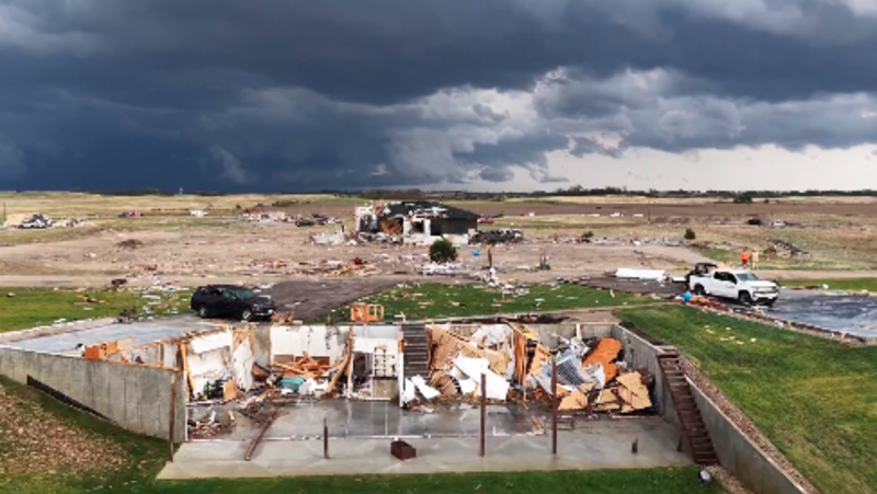
Storm activity reached a critical level over the weekend, with Sunday marking the prelude to Monday’s intense outbreak. Reports of tornadoes, hail the size of baseballs, and winds surpassing 70 mph emerged from Nebraska, Kansas, and South Dakota, spilling into northwest Iowa. These severe conditions were driven by quickly forming thunderstorms that swept through the region, leaving destruction in their path. Footage from central Nebraska captured the chaos as tornadoes damaged homes and structures, with particular impact in St. Libory, Howard County, where a storm near Grand Island caused extensive damage and prompted emergency responses.
“Multiple structures were damaged, and video at the scene showed two people and a dog being rescued from the basement of a collapsed home,” stated Howard County Emergency Management. Though no fatalities or injuries were initially reported, the incident highlighted the destructive power of these storms, which could escalate further as the system strengthens.
Forecasters Sound Alarm for Strong Tornado Potential
As the storm system intensifies, the National Weather Service has flagged a rare Level 4 risk for severe thunderstorms, spanning central Kansas to northwest Missouri and southwest Nebraska. This classification, which appears only 14 times annually, indicates a heightened likelihood of tornadoes rated EF2 to EF3 or higher. Supercell storms expected between 1 p.m. and 5 p.m. CT on Monday may produce softball-sized hail and winds capable of toppling trees. Cities like Manhattan, Topeka, and Wichita face elevated risks, with rapid deterioration in conditions anticipated.
Weather models predict that the most hazardous storm activity will focus on the Central Plains by late Monday afternoon. These supercells will not only spawn tornadoes but also bring torrential rain, increasing flash flood risks. The Storm Prediction Center has noted that severe storms could extend from the Great Lakes to Oklahoma and northwest Texas, driven by a strong jet stream interacting with ample moisture. The combination of these factors creates an environment ripe for extreme weather events, including rare high-end tornado threats.
Storm Spread and Evolving Hazards
As Monday progresses, the storm system will shift eastward, targeting the Lower Missouri Valley and Mid-Mississippi Valley by late evening. While tornadoes may still occur into the overnight hours, the focus will transition toward damaging winds and heavy rainfall. The convergence of intense precipitation and already saturated ground conditions is expected to heighten flash flood risks, particularly in west-central Missouri and far-east-central Kansas. Emergency services are also monitoring fire threats, as dry and windy conditions in the Southern High Plains could reignite wildfires, especially in areas like southwestern Kansas and the Texas Panhandle.
Residents in high-risk zones are advised to secure properties and stay indoors as the storm system evolves. The National Weather Service has warned that the same atmospheric setup responsible for the rare high-end tornado threat will persist through Tuesday, ensuring the threat of severe weather remains active. This prolonged period of instability means communities must remain alert, as the storm’s impact could extend well beyond the initial peak on Monday.
Broader Severe Weather Outlook
Though the peak of the storm outbreak is expected to pass by Tuesday, the threat of severe weather will linger across a vast region. A Level 2 risk for tornadoes has been maintained from northern Texas to Michigan, with damaging winds and hail possible in multiple states. This widespread activity highlights the interconnected nature of weather patterns, where the rare high-end tornado threat in the Central Plains is part of a larger system affecting the entire Midwest and southern Great Lakes. Meteorologists emphasize that the outbreak’s intensity is a result of favorable atmospheric conditions, including warm air masses and strong wind shear.
As the week unfolds, the rare high-end tornado threat will gradually diminish, but the risk of severe weather will not vanish. Officials urge continued monitoring, as the storm system’s remnants could still bring heavy rain and gusty winds to the East Coast by late Tuesday. This dynamic weather scenario serves as a reminder of the unpredictable nature of tornado outbreaks and the importance of preparedness in regions prone to extreme conditions.
