Brewing nor’easter to stir up days of trouble for the Outer Banks and Mid-Atlantic

Daftar Isi
Coastal Storm Could Bring Days of Wind, Flooding and Rough Surf to the Mid-Atlantic
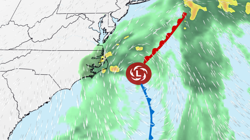
Activelifezero.com – Communities from North Carolina’s Outer Banks to the Chesapeake Bay could face several days of difficult coastal weather as a developing nor’easter takes shape this weekend and lingers into next week.
The storm is not expected to match the path or intensity of the nor’easter that affected the region last month. Even so, its slow movement near the Carolinas could create an extended stretch of powerful wind, elevated tides, pounding surf and beach erosion concerns.
Wind hazards expected to build through Monday
Wind will be the broadest and most persistent impact. Conditions are forecast to deteriorate late Saturday after a strong cold front crosses the Mid-Atlantic and eastern North Carolina. The front will bring rain, a sharp drop in temperatures and increasingly gusty winds.
After the front passes, frequent gusts between 30 and 40 mph are possible around the Chesapeake Bay and across inland portions of eastern North Carolina. The Outer Banks could see stronger gusts reaching 50 mph.
The wind threat is expected to increase Sunday as low pressure develops offshore of North Carolina. By Sunday afternoon, parts of the Outer Banks may experience gusts near 60 mph. Gusts approaching 50 mph could extend farther inland across North Carolina and into coastal sections of Virginia and Maryland.
Those wind speeds may topple tree limbs, damage weaker trees and bring down power lines, creating the possibility of scattered outages. Residents in exposed coastal areas may also encounter hazardous driving conditions, particularly on bridges, elevated roads and routes vulnerable to blowing sand or water.
The strongest winds are tied to the developing storm’s interaction with high pressure over southeastern Canada. Air compressed between the two weather systems will accelerate toward the coast. If the offshore storm strengthens more than currently expected, wind speeds could rise as well.
Nor’easter likely to be established by Monday
By Monday afternoon, the coastal system is expected to be fully organized as a nor’easter. That is also when coastal winds may reach their highest levels and rain begins spreading more widely through the region.
Widespread flash flooding is not expected to be the central concern. Still, rain driven sideways by strong wind could make travel and outdoor activity unpleasant. The Outer Banks could again see gusts above 60 mph, while gusts of 40 to 50 mph may push toward the Interstate 95 corridor in North Carolina and southern Virginia.
Even locations well north of the storm’s center could feel its effects. Coastal Delaware and New Jersey may see gusts up to 30 mph while the system remains close to the Carolinas.
Strong winds are likely to continue Tuesday across North Carolina and portions of the Mid-Atlantic, with only a modest easing possible Wednesday. The later-week outlook is less certain because it depends on how long the storm loops or stalls near the Carolinas. Breezy to windy conditions along the coast could persist into next weekend if the system remains nearby.
Repeated high tides could cause coastal flooding
Coastal flooding may begin as early as Sunday morning’s high tide from the Outer Banks northward through the Chesapeake Bay. Persistent onshore winds will push water toward the coastline, raising water levels during successive tide cycles.
Flooding could worsen by Sunday afternoon, when some areas may reach moderate coastal flooding levels. The Virginia-North Carolina border region is among the places with heightened concern. Additional rounds of moderate flooding are possible around Monday’s high tides, and the recurring pattern could continue at least into the middle of the week.
How close the storm remains to shore will be especially important. A track nearer the coastline could allow some locations to experience major coastal flooding. Coastal residents should pay close attention to local tide forecasts, flood alerts and any road closures, since saltwater flooding can affect low-lying streets well beyond the immediate beachfront.
Heavy surf may worsen erosion along vulnerable beaches
Large waves and rough seas will accompany the flood threat from later this weekend through much of next week. The prolonged surf could accelerate erosion on beaches already exposed to repeated storms.
The Outer Banks are particularly vulnerable because some stretches of shoreline have experienced severe erosion in recent years. Homes have collapsed into the ocean in affected areas, and roadways have been damaged or washed away. Several days of relentless wave action could further stress dunes, beach access points and coastal infrastructure.
Conditions in the surf and near inlets may become dangerous long before any flooding reaches its highest point. Rough water, powerful currents and wind-driven waves can make beaches hazardous even when rain is limited.
Storm is not tropical, though its evolution will be watched
The system is expected to form along the cold front responsible for this weekend’s cooler weather, meaning it will not begin as a tropical storm. Tropical systems draw their energy primarily from warm ocean water, while this developing nor’easter will initially be powered by contrasts in the atmosphere along the front.
However, the storm may remain over relatively warm water just offshore for several days, perhaps as long as a week. That could give it some hybrid characteristics, drawing energy from both the ocean and the atmosphere.
A transition into a tropical system is considered unlikely, though it cannot be ruled out later next week. Such a change would not necessarily alter the practical threats for the coast: damaging winds, elevated water, dangerous surf and erosion would remain the principal concerns.
For residents and visitors along the Outer Banks, the Chesapeake Bay and nearby Mid-Atlantic coastlines, the key message is the duration of the event. Rather than a brief period of bad weather, the developing nor’easter could bring repeated impacts across several tide cycles and multiple days of strong wind.
Related Reading
Frequently Asked Questions
What is Brewing nor easter to stir up days?
Brewing nor easter to stir up days is the main topic of this guide. The article explains the context, practical details, and next steps readers should understand.
Why does Brewing nor easter to stir up days matter?
Brewing nor easter to stir up days matters because readers are looking for a useful answer, not just a short summary. Good content should match search intent and help them decide what to do next.